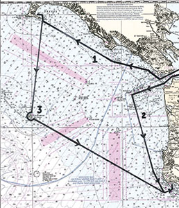
A major question facing all skippers headed south is when to make the turn in that direction. The farther west you go before turning south, the longer the trip will be. I have seen boats turn soon after passing Mile Rocks Light. Older charts show a “South Channel” paralleling the beach just south of the Cliff House Restaurant. Every few years, a boat gets caught in the breakers along that beach, so I never take that shortcut.
With the predominant swell coming from the northwest, it is often completely safe to cross the southern side of the bar surrounding the Gate. The swell would have to be quite big to break here, where the shallowest depths are over 30 feet. Even so, when I am with students for whom it is usually their first trip out the Gate, I always go out the Main Ship Channel.
The Main Ship Channel, as the name implies, is where the big ships cross the bar. It is 2,000 feet wide, dredged to a depth of about 50 feet and is about 2.5 miles long. There are four red buoys marking the south side and four green buoys marking the north. While 2,000 feet may sound quite spacious for a 45-foot sailboat, when there are two 850-foot container ships in that channel, I don’t want to be there. I like to parallel the south side of the channel, just outside the red buoys where there is plenty of water for my boat and I am safe from the big ships. At the outermost red buoy (R“2”), I turn south and it is approximately 20 miles to Pillar Point Harbor.
I shape our course (#2 on the chart) for the buoy that guards Colorado Reef off Pt. Montara (R“26”) and from there to the sea-buoy at Pillar Point Harbor (“PP”). This keeps us well clear of the shore and also out of the lane used by large ships approaching San Francisco from the south. On this sail, I have seen several whale species: California greys, Pacific humpbacks, pilot whales, and once a blue. On several occasions, I’ve seen ocean sunfish and once a whale shark (the world’s largest fish) that must have been 30 feet long. We compared it to the boat we were sailing, which was 34 feet long.
From “PP” (where we radio the harbormaster for a slip), it is only about 1.5 miles to the pass through the reef and then another mile to the outer breakwater. On the way in we pass Mavericks, the world-famous big-wave surf spot.
Once we are secure in our slip and the boat is tidied up, tradition requires us to adjourn to Barbara’s Fish Trap and choose from its very large selection of beers. By then it’s 6:30 p.m. and I’m ready for a margarita before dinner at nearby Mezza Luna. An excellent Italian meal, sharing a fine red wine—then a leisurely stroll back to the boat and a good night’s sleep. In the morning, we will sail back to the San Francisco Bay. A wonderful end to a great trip.
If you can make it a three-day weekend, sail up to Drakes Bay (as described last month), make a predawn departure and then round Southeast Farallon Island just after dawn (#3 on the chart). That’s feeding time for the largest sea bird colony south of Alaska. There are a quarter of a million birds on these rocky isles, plus whales, sea lions and sharks. Then on to Pillar Point Harbor.
Ray Wichmann, is a US SAILING-certified Ocean Passagemaking Instructor, a US SAILING Master Instructor Trainer, and a member of US SAILING’s National Faculty. He holds a 100-Ton Master’s License, was a charter skipper in Hawai’i for 15 years, and has sailed on both coasts of the United States, in Mexico, the Caribbean, and Greece. He is presently employed as the Master Instructor at OCSC Sailing in the Berkeley Marina.

