Published: August, 2007
In addition, an expanded water-transit system provides critical transportation resources for emergency planners in case of a natural or manmade disaster that disables roads, tunnels or bridges. Expanded ferry service is also a catalyst for smart land-use planning for new residential and commercial developments.
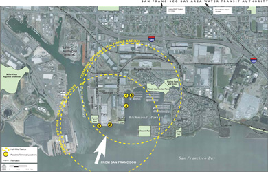
On July 12th, the WTA held the third Richmond Ferry Terminal Stakeholders Meeting regarding a future Richmond ferry terminal location and associated transit-oriented development. At the second Stakeholders Meeting, last September, the WTA and its team of consultants presented five alternative development concepts for the Ford Peninsula. The purpose of this meeting was to present the WTA’s preferred location for the ferry terminal, explain the reasoning behind the decision, and respond to various issues and concerns that have been raised in past meetings.
The vision for future ferry service in Richmond includes creating a waterfront transit-oriented development that expands the existing residential neighborhood, provides local-serving retail stores, knits together existing waterfront land uses, and provides additional employment opportunities while preserving existing employment opportunities and supporting long-term ferry service. The envisioned ferry service is not just intended for Richmond-based commuters; it would also provide a means for recreational travel to Richmond’s extensive waterfront park system, the Bay Trail, the Ford Point Building, and the Rosie the Riveter/World War II Home Front National Historical Park.
In order to obtain MTC funding for the development of ferry services in Richmond, a minimum of 1200 rooftops must be located within ½ mile of the proposed terminal. Of the five locations previously identified along Ford Point and Marina Bay, only the three locations at the northwest corner of Marina Bay currently provide the necessary residency requirements to obtain the critical MTC funding.
Of the three Marina Bay locations considered, Signature Point—just south of the new Anchor Cove Condominiums—was chosen as the most viable and presented as the Preferred Development Alternative by the WTA. This location would be directly adjacent to a retail site that will be developed by Signature Properties. The current plan for the Signature commercial development includes a waterfront plaza and commercial space including new shops, office space and restaurants in up to six buildings, all designed to create an outdoor-themed retail experience.
A transit-oriented development market study done by Bay Area Economics concluded that the addition of ferry service to Richmond’s Marina Bay would bring more developments and residents to the area. This, in turn, would attract local-serving retail stores, restaurants and services. A node including restaurants and specialty shops included in the Signature plan will attract consumers from outside the neighborhood, thereby increasing the chances of retail and transit-oriented development success.
It is important to note that the WTA does not have the authority to make the final decision on what land uses are allowed. That authority rests with the city of Richmond. The WTA is responsible for making sure that the land uses developed around potential terminals will be supportive of water transit. The presentation of the Preferred Development Alternative at Signature Point in Marina Bay is suggested by the WTA as the most favorable site available to attract ferry service to Richmond in the future.
Richmond Community Redevelopment Agency
Office of Economic Development
(510) 307-8140 Richmondca4business.com


