By Captain Ray
Published: June, 2010
Last week was one of these times for me. Dorothy and I took the train from Emeryville to Reno, stayed overnight, had dinner and took in a show. The next morning, we rode the train back to Emeryville. The train was Amtrak’s California Zephyr; its route runs between Emeryville and Chicago. Every day a train starts the two-day journey from either end. For us, it was just the first six hours of the trip—up and over the still-snowy Sierra.
One of the pleasures of train travel is the opportunity to sit back, relax and watch the ever changing scenery unroll before you. Often what you see are grand long-distance vistas; that is certainly true as the train climbed up to Donner Summit. Occasionally, however, you get a close-up view of something that is usually only visible from a distance.
The pleasure of watching the scenery slip past you is something train travel shares with ferry travel. For instance, the trip on the Vallejo Ferry gives you a grand view of Mount Tamalpais as well as vast amounts of the San Francisco and San Pablo Bay shorelines—from a distance. Unfortunately, much of what you see is inaccessible from the water. A quick look at a nautical chart reveals that, between Point San Pablo and Carquinez Strait, the water along the east shore of San Pablo Bay is so shallow for so far offshore that it is impossible for boats to get in very close. In many places, it is only two or three feet deep as much as a mile offshore. While it is true that the Vallejo Ferry comes close to the tip of Point Pinole, most of the shoreline is as much as two miles away.
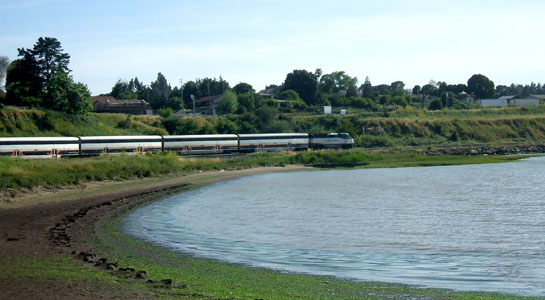
Amtrak’s California Zephyr, on the other hand, spends 15 to 20 minutes wending its way along that very shoreline. My seat on the left side of the train gave me an unobstructed close-up view of that section of the Bay shore. After passing through Richmond, there is a large wetland extending to the waters of the Bay, with the mountains of Marin County in the distance. The train then cuts across the base of Pinole Point and from that point travels right along the shoreline until it reaches the refineries in Rodeo.
What unfolded outside my window was a series of small scalloped beaches separated by rocky headlands and low cliffs. Most of the beaches were pebbly, but there was even a sandy one. Because the tracks were constructed right along the shore, there isn’t much space between the embankment and the beach. The tide was high and the water appeared to be just outside the window.
On the return trip, the tide was out and it was clear just how shallow the area is. Expansive areas of mud lay exposed to view. It was very apparent why vessels cannot approach this shoreline and why, from a ferry, it can only be viewed from a distance. To get a close-up view, take the train! It is a quite lovely stretch of coast, and you’ll appreciate the opportunity to see it from the other side.
Ray Wichmann, is a US SAILING-certified Ocean Passagemaking Instructor, a US SAILING Instructor Trainer, and a member of US SAILING’s National Faculty. He holds a 100-Ton Master’s License, was a charter skipper in Hawai’i for 15 years, and has sailed on both coasts of the United States, in Mexico, the Caribbean, and Greece. He is presently employed as the Master Instructor at OCSC Sailing in the Berkeley Marina.

